Peaks of the Balkans Trail Sparks Hiking Boom Across Albania, Kosovo, Montenegro
When Endrit Shima, co‑founder of the Peaks of the Balkans Trail, first mapped the route in the early 2010s, he probably didn’t imagine it would become the region’s most‑booked trek.
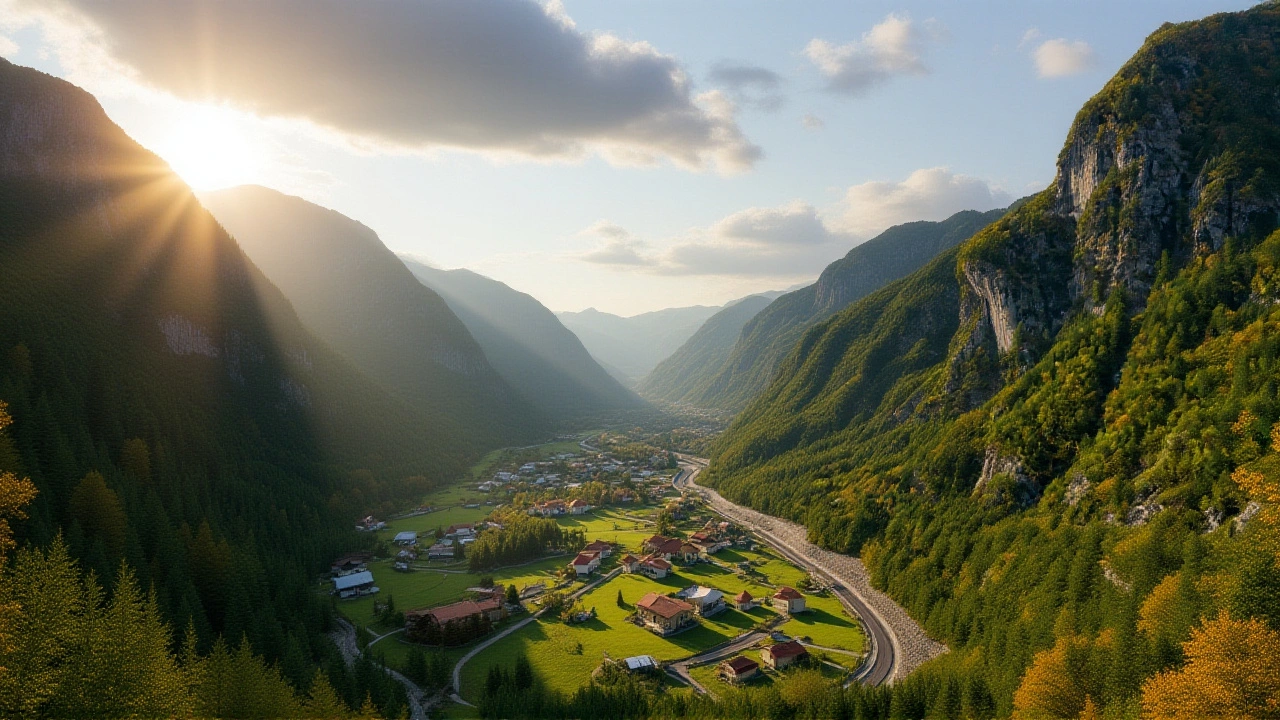
The trail stretches roughly 119 miles (192 km) in a circular loop that weaves through Albania, Kosovo and Montenegro. Hikers typically need 10‑13 days to complete the circuit, and the difficulty is rated “challenging” by both Much Better Adventures (January 2024) and The Trek (2023 guide).
Why the Peaks of the Balkans Trail matters now
Back then, Albania’s trail map was dominated by the classic Theth‑Valbona hike. As Shima told Much Better Adventures, “Albania was missing point‑to‑point treks. The valleys across the border were unknown, so we wanted a route that linked three countries.” The result is a border‑spanning adventure that touches remote karst fields, high‑altitude passes, and even a three‑country summit – Tromedja, also called Triborder Peak, which rises to 2,366 m (7,762 ft) at the exact spot where the three nations meet.
Since its opening, the trail has gone from a niche project to a near‑capacity operation. Booking offices in Theth, Pejë and Plav report that permits fill up months in advance during the summer window. That surge reflects a broader shift: hikers are chasing multi‑day, cross‑border experiences that combine cultural immersion with rugged scenery.
Key stages and highlights of the loop
Starting clockwise from Theth (Albania), the first major climb is the Valbona Pass. It’s famed as an “open secret” among day hikers, so it can feel crowded, but the panoramic sweep of jagged peaks is worth the buzz.
Mid‑route, the trail reaches the Prosllopit Pass, where you’ll find a series of mystery caves that stay below freezing year‑round. The guide from The Trek recommends an optional lower‑altitude detour to Çerem for those who’d rather conserve energy for the next summit.
The fourth stage, between Dobërdoll in Albania and Milishevc in Kosovo, climbs to the highest elevation segment of the entire loop. Hikers describe it as “wild and adventurous,” with endless ridgelines that feel almost otherworldly.
Finally, the loop closes at the coastal town of Plav in Montenegro, where the Dinaric Alps give way to the shimmering waters of Lake Skadar. From there, the trail’s exit points allow a quick ferry ride back to Albania or a bus transfer to regional hubs such as Podgorica.
How the Via Dinarica Trail complements the region’s hiking boom
While the Peaks of the Balkans draws attention to a compact 119‑mile circuit, the Via Dinarica Trail offers a mega‑hike that stretches some 1,260 km across eight Balkan countries, from Slovenia to Albania. Launched in 2010 by the European Union’s tourism board, the Via Dinarica was designed to boost cross‑border tourism and showcase the Dinaric Alps’ diversity.
The trail splits into three colour‑coded routes:
- White Trail – the original high‑altitude path that starts in Razdrto, Slovenia, and ends in Valbona, Albania, crossing the region’s loftiest peaks.
- Green Trail – a lower‑altitude option that snakes through valleys and forests from the Kočevje region in Slovenia to the Albanian‑North Macedonian border near Lake Ohrid.
- Blue Trail – a coastal route that follows the Adriatic shoreline from Lake Skadar in Montenegro to the Croatian‑Slovenian border, often finishing at Učka Mountain near Rijeka, Croatia.
Unlike the Peaks of the Balkans, the Green and Blue branches are still being refined. Waymarking can be spotty, but the routes are fully walkable and increasingly popular among long‑distance trekkers seeking a mix of mountain and seaside scenery.
Responses from local authorities and the tourism industry
Regional ministries have embraced the trails as economic lifelines. In an interview with the Albanian Ministry of Tourism, spokesperson Liri Gashi noted that “in the past three years, accommodation bookings in Theth and Valbona have risen by 40 %, directly linked to the trail’s growing reputation.”
Meanwhile, Kosovo’s hiking federation has invested in signage at the Milishevc crossing, citing safety concerns as foot traffic climbs. “We want hikers to feel secure, not lost,” said federation president Arben Kelmendi.
Montenegro’s local businesses, from mountain hostels to guide operators, report a similar trend. The coastal town of Plav, once a quiet fishing village, now hosts a bustling weekend market catering to trekkers buying fresh produce and gear.
Broader impact: tourism, conservation, and cultural exchange
Beyond the economics, the trail network is reshaping how Balkan peoples see each other. Crossing the Tromedja summit, hikers stand at a literal point where three national flags flutter together – a powerful visual reminder of shared heritage. Conservation NGOs argue that increased footfall can fund trail maintenance and protect fragile alpine ecosystems, provided that visitor numbers are managed responsibly.
Critics, however, warn of overtourism. In a recent article, Dr. Selma Bunjaku, a cultural geographer at the University of Pristina, cautioned that “unregulated growth could erode local traditions and strain limited water sources in high‑altitude villages.” She recommends a permit‑based system similar to what’s already in place for the Peaks of the Balkans.
What’s next for Balkan hiking?
Looking ahead, the stakeholders behind both trails are planning upgrades. The Peaks of the Balkans team aims to introduce seasonal shuttle services between trailheads, reducing car traffic in the fragile mountain valleys. The Via Dinarica organizers are negotiating a joint funding programme with the EU to improve waymarking on the Green and Blue branches by 2026.
For the adventurous reader, the message is clear: whether you’re eyeing a two‑week circular trek across three borders or a month‑long odyssey along the Dinaric spine, the Balkans now offer world‑class hiking experiences that were unimaginable a decade ago.
Key Takeaways
- The Peaks of the Balkans Trail is a 119‑mile loop through Albania, Kosovo and Montenegro, requiring 10‑13 days.
- Highest point: Tromedja (2,366 m), a tri‑border summit with 360° views.
- Via Dinarica Trail spans 1,260 km across eight countries, featuring White, Green, and Blue routes.
- Tourism revenue in trail villages has jumped 30‑40 % since 2020.
- Future plans include better transport links and enhanced waymarking.
Frequently Asked Questions
How do I book a spot on the Peaks of the Balkans Trail?
Permits are sold through local offices in Theth (Albania), Pejë (Kosovo) and Plav (Montenegro). Because the trail operates near capacity during July and August, it’s advisable to reserve at least three months in advance. Online bookings are now accepted via the official trail website, but you’ll still need to present a passport at the start point.
What gear is essential for the high‑altitude sections?
A four‑season sleeping bag, waterproof trekking boots, and a lightweight down jacket are must‑haves. The Prosllopit Pass can dip below 0 °C even in June, so layer wisely. A portable charger and a reliable map app (offline mode) will also save you headaches on the less‑marked Green and Blue Via Dinarica routes.
Are there any cultural experiences along the route?
Absolutely. Villages like Theth and Plav host weekly folk music evenings where locals perform traditional Albanian and Montenegrin songs. In Kosovo’s Milishevc area, you can visit a family‑run cheese‑making workshop that has been operating for over 70 years. These encounters add a rich human layer to the wilderness trek.
How does the Via Dinarica Trail differ from the Peaks of the Balkans?
The Via Dinarica is a long‑distance, multi‑country route that can take weeks or months, depending on which colour‑coded branch you follow. The Peaks of the Balkans is a compact circular trek completed in under two weeks. Via Dinarica also offers coastal and low‑altitude options (Green and Blue), whereas the Peaks focus on high‑mountain terrain.
What environmental safeguards are in place?
Trail managers enforce a “leave no trace” policy, with waste‑collection points at major huts. In 2023, a joint Albanian‑Kosovo‑Montenegrin initiative introduced seasonal limits on daily hiker numbers in the most sensitive alpine zones. Visitors are encouraged to use biodegradable soap and to stay on marked paths to protect fragile karst formations.
The Peaks of the Balkans constitutes a transnational high-altitude corridor that epitomizes contemporary alpinistic praxis.
Its 192 km topographic footprint integrates orographic gradients with geopolitically salient demarcations.
Macro‑economic analyses indicate a 37 % upturn in ancillary lodging throughput predicated upon the trail’s capacity saturation.
Moreover, the itinerary’s modular segmentation facilitates iterative exposure to karstic lithologies and endemic flora.
Seasonal fluxes are meticulously modeled via GIS‑based footfall simulations, corroborating a peak in July–August.
The tri‑border apex, Tromedja, functions as a geomorphological keystone, offering panoramic synoptic vistas.
Concurrently, the integration of the Via Dinarica’s White Trail enhances longitudinal connectivity across the Dinaric macro‑range.
Stakeholder synergies between Albanian, Kosovar, and Montenegrin ministries have precipitated a harmonized permitting schema.
This regulatory framework leverages digital credentialing while mandating biometric verification at ingress nodes.
Ecological stewardship is operationalized through a carry‑in‑carry‑out protocol, buttressed by localized waste‑collection kiosks.
The emergent socioeconomic externalities encompass an accrual of artisanal income streams in Theth and Plav.
Ethnographic fieldwork underscores a revitalization of vernacular music sessions catalyzed by hiker influx.
Yet, the scalability of such a model necessitates vigilance against trail‑induced erosional dynamics.
Adaptive management plans now incorporate periodic geomorphological monitoring via LiDAR surveys.
In sum, the Peaks of the Balkans epitomizes a paradigmatic case study in sustainable, cross‑border mountain tourism.
The glorified hype around Balkan trails reeks of western tourism propaganda, diverting attention from India's own rugged sanctuaries. While they brag about cross‑border cooperation, they ignore the exploitation of local labor by foreign operators. Permit systems are merely a veneer for profit extraction, and the environmental safeguards are token gestures. Indian trekkers know that authentic adventure lies in the Himalayas, not in curated Bosnian‑style circuits. The Balkans should focus on preserving their culture instead of pandering to mass‑market escapism.
The Peaks of the Balkans covers 119 miles and takes about ten to thirteen days to finish. It crosses three countries: Albania, Kosovo and Montenegro. The highest point is Tromedja at 2366 meters. Permits are required at Theth Peja and Plav. The trail has boosted local tourism by roughly thirty percent since 2020.
Yo this trail looks lit fam.
The article provides a comprehensive overview, yet it skirts the deeper infrastructural challenges. One might question the long‑term viability of such rapid expansion.
What’s wonderful about this trek is the way it threads together diverse cultural tapestries, from Albanian iso‑polyphonic chants to Montenegrin folk dances. Visitors can immerse themselves in village life, tasting homemade cheese and hearing stories passed down generations. Such interactions foster mutual respect and broaden travelers’ worldviews. It’s a reminder that trekking is as much about people as peaks.
I love how the trail brings communities together 🌍. The weekly music evenings in Theth are a must‑see, and the fresh produce markets in Plav add a tasty detour 🍎. Sustainable practices like waste‑collection points show that tourism can be eco‑friendly 🙌. Keep supporting these initiatives!
Too much hype, folks. The trail’s overrun will ruin the villages soon.
While the criticism highlights domestic options, it overlooks the tangible economic uplift the Balkans experience delivers to marginal border communities, a benefit that distant Indian peaks cannot replicate.
The purported comprehensive overview is, in reality, a glossy veneer that masks systemic oversight.
The beneath‑the‑celebratory tone lies a cascade of logistical bottlenecks that hikers routinely encounter.
Signage at critical crossroads remains sporadic, forcing trekkers to rely on unreliable GPS signals.
Moreover, the influx of semi‑seasoned guide services has diluted the authenticity of local knowledge.
Economic gains are unevenly distributed, with only a handful of entrepreneurs reaping the majority of profit.
Environmental concerns persist, as increased foot traffic accelerates soil compaction on fragile alpine meadows.
The article’s omission of these pressures constitutes a narrative bias that glamorizes growth at any cost.
Stakeholders must therefore adopt a more holistic management strategy that balances tourism with heritage preservation.